Detailed description of Rockhurst University campus map
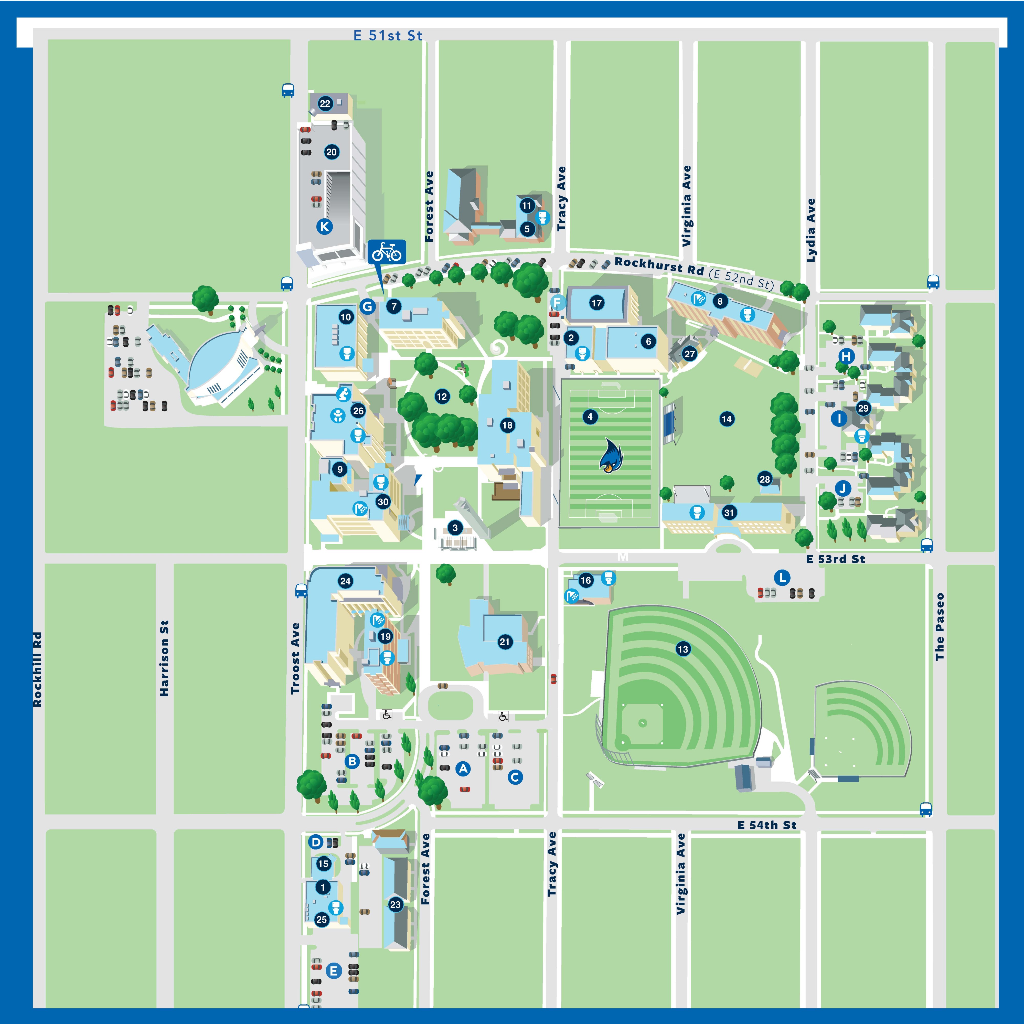
This is an illustrated map of Rockhurst University’s campus in Kansas City, Missouri, oriented with north at the top.
Surrounding streets
- E 51st Street borders the campus to the north.
- E 52nd Street (Rockhurst Road) runs east–west through the upper portion of campus.
- E 53rd Street and E 54th Street run east–west along the middle and southern edges.
- Troost Avenue forms the western boundary.
- Forest Avenue, Tracy Avenue, and Virginia Avenue run north–south through campus.
- The Paseo borders the far eastern edge.
Campus layout
The main academic campus is centered between Rockhurst Road (E 52nd St) and E 53rd Street. Buildings are arranged around a central quad with sidewalks connecting all major areas. Trees and green space are distributed throughout.
Academic and administrative buildings
Multiple academic buildings are clustered in the central and western portions of campus, particularly between Troost Avenue and Tracy Avenue. These include classroom buildings, administrative offices, and student services. A larger academic complex is located just south of Rockhurst Road near the center of campus.
Student facilities and gathering spaces
The central quad includes open green space, seating areas, and pedestrian pathways connecting key buildings. A chapel and student-centered facilities are located within the main campus core.
Residence halls
Student housing is primarily located on the east side of campus, between Virginia Avenue and The Paseo, north and south of E 53rd Street. These buildings are grouped in clusters with nearby parking and pedestrian access.
Athletic facilities
- A soccer field is located east of the central campus, just north of E 53rd Street.
- Baseball and softball fields are located in the southeast portion of campus, south of E 53rd Street and north of E 54th Street.
- Additional athletic and recreational spaces are distributed nearby.
Parking
Multiple parking lots are labeled with letters (A through L) and are located throughout campus:
- Larger parking areas are concentrated along the southern edge near E 53rd and E 54th Streets.
- Additional lots are located near residence halls and along the western and northern edges.
Transportation and accessibility
Bus stops are marked along major streets, including Troost Avenue and Rockhurst Road. Accessibility icons indicate accessible entrances and routes near key buildings and parking areas.
Additional features
A parking garage is located near the northwest portion of campus along Forest Avenue. Green spaces, trees, and pedestrian walkways connect all major areas, creating a walkable campus environment.
Buildings
- Alvin Brooks Center for Faith-Justice
- Ignatian Spirituality Center
- KC Common Good
- Athletic Department
- Bell Tower, Pergola and Fountain
- Bourke Field
- Campus Ministry Center
- Convocation Center
- Conway Hall
- Human Resources, Room 103
- Corcoran Residence Hall
- Greenlease Gallery
- Greenlease Library
- Kateri Community Residence
- Kinerk Commons
- Loyola Park
- Lower Bourke Field
- Mabee Chapel
- Magis Activity Center
- Mason-Halpin Fieldhouse
- Massman Hall
- Admissions, Second Floor
- Dining Room, First Floor
- Registrar’s Office/Financial Aid, First Floor
- Bookstore, Basement Level
- McGee Residence Hall
- North Parking Garage
- Catholic Charities of Kansas City-St. Joseph
- Saint Luke’s Convenient Care
- Truman Library Institute
- Pedro Arrupe, S.J., Hall
- Physical Plant Operations
- Rock Row Housing
- St. Ignatius Science Center
- Security Department
- Sedgwick Hall
- Student Activities Hall
- The Birdhouse
- Town House Village
- Van Ackeren Hall
- Xavier-Loyola Residence Hall
Parking
- Bellarmine
- Borgia
- Brown
- De Acosta
- De Chardin
- Hopkins
- Kino
- Mayer
- Miki
- Murray
- Parking Garage
- Faber
Accessibility Features
- All-gender restrooms
- Lactation room
- Multifaith prayer room