Remote blue strobe security phones are located at strategic locations around the Rockhurst University campus.
Detailed Description:
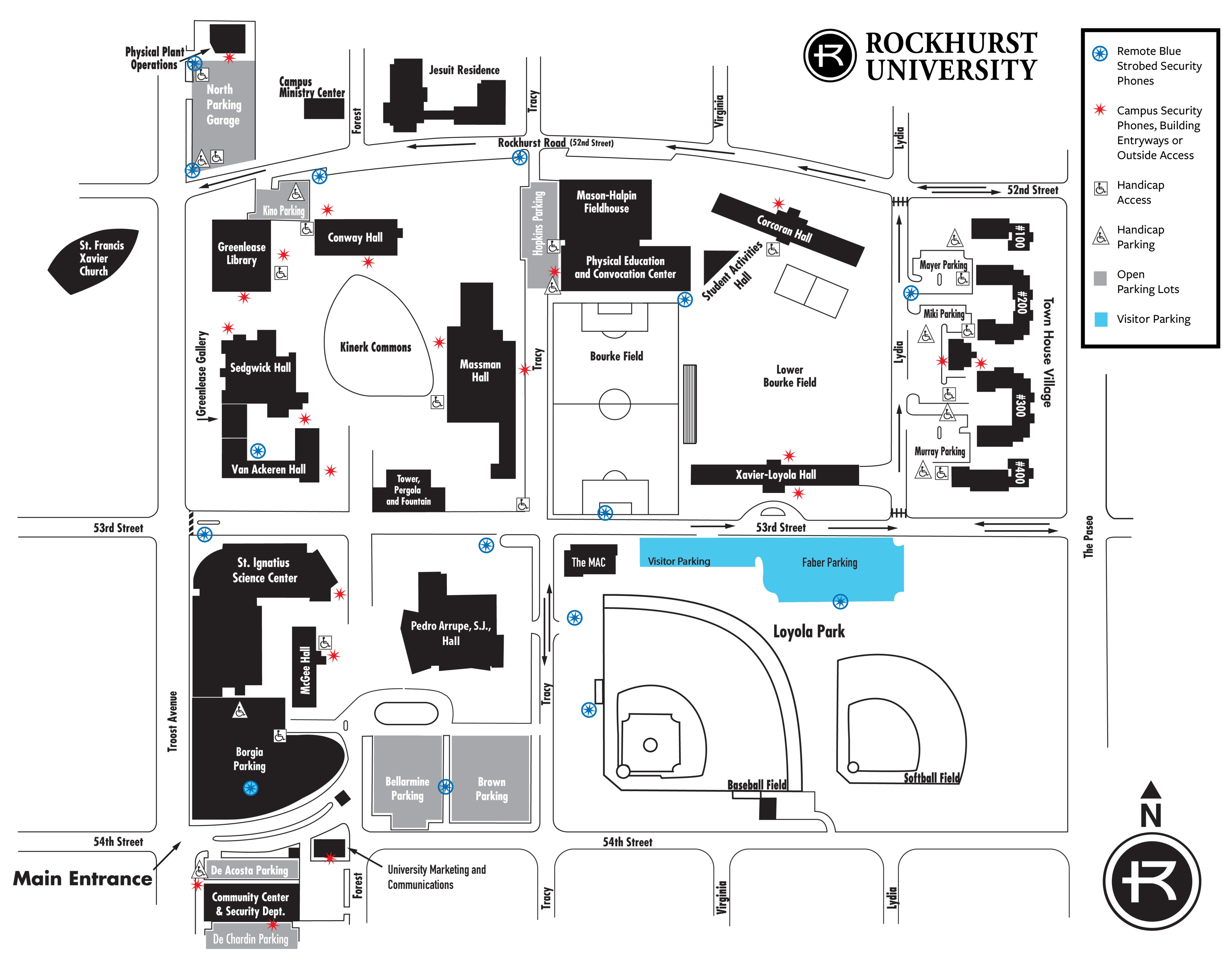
Rockhurst University Campus Security Map Description
This map shows the layout of Rockhurst University’s campus, including academic buildings, residence halls, parking lots, athletic facilities, and nearby streets. It also identifies safety and accessibility features such as emergency blue light phones, campus security phone locations, handicap access points, handicap parking, and general parking areas.
Orientation and Streets
The campus is bordered by 51st Street to the north, 53rd Street running through the center, and 54th Street to the south. Troost Avenue runs along the west side, and Paseo Boulevard borders the east side. Rockhurst Road runs east–west through the northern portion of campus.
Main Entrance
The main entrance is located at the southwest corner of campus near 54th Street and Troost Avenue.
Academic and Administrative Buildings
- Greenlease Library is located in the northwest central area.
- Conway Hall sits east of the library along Rockhurst Road.
- Massman Hall is centrally located on the main quad.
- Sedgwick Hall and Van Ackeren Hall are west of Massman Hall.
- St. Ignatius Science Center is located in the southwest quadrant.
- Pedro Arrupe, S.J. Hall is southeast of the science center.
- University Marketing and Communications and the Community Center and Security Department are near the main entrance.
Athletic and Recreation Facilities
- Bourke Field is centrally located east of Massman Hall.
- Lower Bourke Field is directly east of Bourke Field.
- Mason-Halpin Fieldhouse and the Physical Education and Convocation Center are north of Bourke Field.
- Loyola Park, including baseball and softball fields, is located in the southeast portion of campus.
Residence Halls
- Xavier-Loyola Hall is located south of Lower Bourke Field.
- Corcoran Hall and Kateri Hall are northeast of the main academic area.
- McGee Hall and other Town House Village residences are located along the eastern side of campus.
Parking and Accessibility
Multiple open parking lots are distributed throughout campus, including areas near the main entrance, Loyola Park, and the eastern residential area. Handicap parking spaces are marked near major buildings. Handicap access points are identified at building entrances.
Safety Features
- Emergency blue light phones are located throughout campus, particularly along main walkways and near parking areas.
- Campus security phones and building entry points are marked near major buildings and residential areas.
Landmarks
- Kinerk Commons is located in the central quad area.
- St. Francis Xavier Church is positioned west of the main campus across Troost Avenue.
Legend
- Blue circles indicate emergency blue light phones.
- Red stars indicate campus security phones or building entry/access points.
- Wheelchair symbols indicate handicap access locations.
- Marked spaces indicate handicap parking.
- Shaded areas indicate general parking lots.
A north arrow is shown in the lower-right corner of the map, indicating the orientation.